 As Hurricane Debby churns toward the Southeast United States, AccuWeather meteorologists have issued a dire warning about the impending life-threatening storm surge and catastrophic flooding. This natural disaster poses a significant threat to public safety, with impacts expected to last well into the workweek.
Rising Threat of Storm Surge and Flooding
AccuWeather’s Chief Meteorologist, Jon Porter, has raised alarms about the dangerous storm surge and the potential for devastating flooding from Hurricane Debby. “We urge people, businesses, and government officials in the storm’s path to frequently check the AccuWeather forecast,” Porter emphasized. “This storm is going to make for a dangerous and long week for residents in parts of the southeastern United States.”
Forecasts predict that Debby will intensify into a hurricane before landfall in the Big Bend region of Florida on Monday. The expected storm surge could reach 6-10 feet, posing a significant threat to life and property. Already, parts of South Florida experienced the initial round of flooding on Saturday night.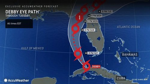
A Path of Destruction
After impacting the Gulf Coast with high winds and heavy rainfall, Debby is expected to move inland across Florida and Georgia, reaching the Atlantic coast of the southeastern U.S. This trajectory means the storm’s impacts will be widespread and long-lasting.
“Debby will produce a variety of life-threatening and significant impacts for days to come,” Porter warned. “Please do not be lulled into a false sense of security by Debby’s current tropical storm status. We’ve seen many situations where the real dangers were underestimated due to the limitations of the Saffir-Simpson Hurricane Wind Scale, which only categorizes storms by wind intensity.”
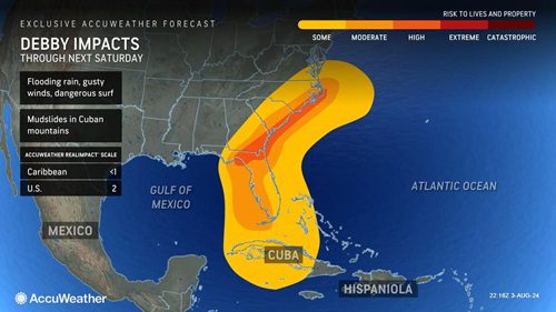
AccuWeather RealImpact™ Scale for Hurricanes
To provide a more comprehensive assessment of Debby’s potential impact, AccuWeather uses its exclusive RealImpact™ Scale for Hurricanes. Unlike the Saffir-Simpson scale, which only considers wind speed, the RealImpact™ Scale evaluates a broader range of factors, including flooding rain, storm surge, and economic damage. Debby is currently rated a 2 on this scale, indicating moderate flooding and significant wind damage, with potential power outages and coastal property damage.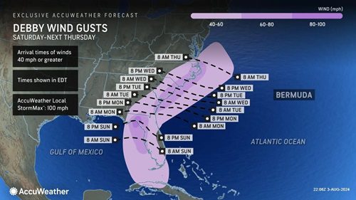
Expanding the High-Risk Zone
On Saturday evening, AccuWeather meteorologists expanded the high-risk zone to include the Big Bend region, northeast Florida, southeast Georgia, eastern South Carolina, and eastern North Carolina. This expansion aims to raise public awareness and give residents more time to prepare for the impending storm.
“The exclusive AccuWeather RealImpact™ Scale for Hurricanes has proven itself incredibly useful,” Porter explained. “While the wind impact will be significant, especially near Debby’s landfall, the storm may be remembered more for water dangers due to significant storm surge and major flooding.”
Potential for Catastrophic Flooding
As Debby moves closer to the U.S. coast, its RealImpact™ Scale rating could be upgraded. Two scenarios could lead to a higher rating: if the storm gains further wind intensity over the warm Gulf of Mexico waters or if it slows down significantly once it reaches the Southeast coast.
Porter noted, “A stalled or slow-moving storm would greatly amplify the impacts, leading to prolonged flooding, major coastal erosion, and other significant hazards.”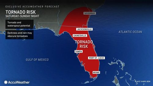
Timeline of Impacts Across the Southeast
Tropical Depression 4 developed into Tropical Storm Debby on Saturday afternoon, intensifying over the warm waters of the eastern Gulf of Mexico. The storm’s westward track across Cuba allowed it more time over these favourable conditions, leading to further strengthening.
Families across the Florida peninsula have been warned to prepare for tornado threats throughout the weekend as Debby approaches the coastline. Sea surface temperatures near or above 90 degrees are expected to fuel the storm’s development over the next 24 hours.
AccuWeather forecasts that Debby will land in the Big Bend region of Florida on Monday as a Category 1 hurricane, with maximum sustained winds of 74-95 mph. However, rapid intensification could elevate Debby to a Category 2 hurricane or stronger.
Inland and Coastal Flooding Concerns
Once Debby moves inland, it will take a northeast track across northern Florida, eventually reaching the Southeast coast of Georgia and the Carolinas. The potential for the storm to slow down or even stall in this region could lead to significant, life-threatening flooding.
“If heavy rain bands persist over the same areas for days, a catastrophic flooding disaster may occur,” Porter warned. “Water flowing towards the coast, coupled with persistent onshore flow, can back up rivers and exacerbate flooding concerns.”
Impact of Powerful Winds and Extreme Rainfall
The Florida peninsula is expected to receive at least 2-4 inches of rain from Debby, with 4-8 inches expected close to the storm’s projected path. Some areas may experience 8-12 inches of rain, with a possible maximum of 25 inches, particularly along the coast of Georgia and the Carolinas.
These rainfall amounts could lead to significant flooding, road closures, and travel delays. Historically, slow-moving tropical storms and hurricanes have caused catastrophic flooding in the U.S., such as Agnes in 1972, Allison in 2001, Harvey in 2017, and Florence in 2018.
Wind gusts of 40-60 mph will extend north along the Southeast coast from the Gulf Coast of Florida. Northern Florida and the Georgia and Carolina coasts may experience 60-80 mph, with possible gusts of 80-90 mph gusts near the landfall point. An AccuWeather Local StormMax™ of 100 mph is possible, which could cause significant structural damage, power outages, and fallen trees.
Coastal and Inland Flooding Risks
As Debby moves over Florida and the Southeast, onshore flow from northeast Florida through the Carolinas will increase. The prolonged onshore flow, coupled with heavy rainfall and river runoff, could lead to life-threatening coastal flooding and significant beach erosion.
Flooding along the sound side of the Outer Banks of North Carolina is also possible, with rivers and waterways potentially backing up due to the combined effects of runoff and onshore flow. Portions of beaches from Georgia to the Carolinas could be washed away, with storm surge expected to reach 3-6 feet and 6-10 feet in some areas.
Rough surf and dangerous rip currents are anticipated at beaches along the Gulf Coast of Florida and the Atlantic coast from Miami to North Carolina.
Preparing for the Worst
As Hurricane Debby approaches, it is crucial for residents in the storm’s path to stay informed and take necessary precautions. Regularly check reliable sources such as AccuWeather for updates and safety advice. The potential for severe flooding and storm surges underscores the importance of preparation and vigilance.
Stay Safe and Informed
Visit AccuWeather for continuous updates and expert forecasts. Stay informed about the storm’s progress and potential impacts to ensure your safety. Being prepared can make a significant difference in mitigating the risks posed by Hurricane Debby.
Final Note
As Hurricane Debby barrels towards the Southeast U.S., the combined threats of storm surge, flooding, and powerful winds highlight the need for immediate action and preparation. Stay informed, heed warnings, and prioritize safety to navigate this dangerous weather event.
Written by: Jason Smith


